Map of Exodus Leaving Egypt
Exodus Map
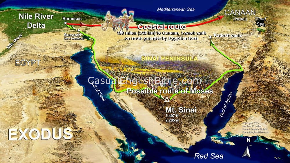
Exodus map of Moses and Hebrews leaving Egypt. The map shows a possible route Moses took when he led the Hebrews to freedom. Many Bibles say Moses and the Hebrews crossed the “Red Sea.” But the Hebrew words are yam suph, “sea reeds.” Later in the story, Moses and the Hebrew refugees will escape through a path God makes in this body of water. Scholars usually track Moses and the Hebrews escaping Egypt by walking southeast, out of the Nile Delta fields. That's toward the Red Sea and the Sinai Peninsula. They would have passed through lake regions along what is now the Suez Canal. This connects the Red Sea to the Mediterranean Sea. These lakes and ponds reportedly had reeds growing along the banks, like the ones the Bible says grew along the Nile River and helped anchor Baby Moses in a basket (Exodus 2:3). Compare with other Bible versions at Bible Gateway.Mount Sinai
Horeb is a Hebrew word that can mean “dry,” “desolate,” or “desert.” But here, it reads more like a name. Most Bible scholars say it’s an alternate name for Mount Sinai—much like “Zion” is another name for “Jerusalem.” Some say the mountain is in Egypt’s Sinai Peninsula. Others say it’s in what is now Saudi Arabia, where the people of Midian lived.Sinai, Land of God
Two Egyptian hieroglyphic inscriptions from about the 1400s BC, around the time some scholars say Moses lived, said the mountainous territory of the Sinai was the “land of the Shasu of Yahweh.” “Shasu” was what Egyptians called the nomads and herders from what is now the areas of Israel, Palestinian Territories, Syria, and Jordan. Yahweh, translated “LORD” in all capital letters, was God’s name (3:14). The inscription might mean the Sinai was the land of nomads who worshipped God or who were known by the name of God—perhaps as “the people of God.” These inscriptions are the two oldest references outside the Bible to anyone worshiping Yahweh, the God of the Israelites, who were ancestors of today’s Jewish people.Leaving Egypt

